Services

Seismoelectric surveys

Seismic investigations are based on the principle that an underground water flow creates a weak electric field which can be measured on the surface with suitable equipment following a strong acoustic impulse created by a normal seismic source (a hammer and a plate, or seismic rifle). There are at least four causes of seismoelectric effects: piezoelectricity, modulation of resistivity, pulsed radio effect (RPE), and electrokinetic effects.

Geophysical surveys

Seismic prospecting is a geophysical investigation method based on the study of the propagation of both natural and artificially generated seismic waves. The main seismic prospecting methods make use of reflected waves (reflection method), refracted waves (refraction method) or environmental noise (passive techniques).

Geoelectric surveys represent a modern non-invasive geophysical survey methodology and are based on the detection of the electrical resistivity of the various types of land investigated.

Geoelectrical surveys

Geoelectric surveys represent a non-invasive geophysical survey methodology and are based on the detection of the electrical resistivity (electrical conductivity) of the various types of land investigated. Conductivity is mainly a function of the chemical (the various types of rocks and soils present in nature, the various materials and compounds) and electrolytic (presence or absence of water, humidity, and dissolved salts) of the rocks and soils themselves. These surveys allow, in the environmental field, the estimation of the thickness of the body of the waste in the landfill or the identification of pockets or paths of leachate.

Electromagnetic surveys

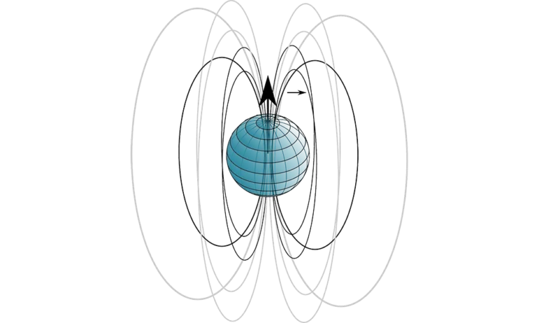
The geophysical survey with the electromagnetic method (EM) is based on the determination of the conductivity parameter of a given medium in which an electromagnetic field has been induced. In particular, he studies the response of the ground when electromagnetic fields (EM) are propagated through it. The different methods, albeit with their own peculiarities, use the generation of an electromagnetic field (EM), called primary, which is transmitted around an emitting coil, inducing a current to circulate in the ground. This in turn will give rise to a secondary EM field, the intensity of which is proportional to the conductivity of the material. The electrical conductivity of soils (the inverse of resistivity) is a parameter that depends on various factors such as the degree of saturation, the salinity of the water in the pores, the mineralogical composition.

Penetration tests

Penetrometric tests are part of geotechnical in situ investigations. They make it possible to indirectly characterize the subsoil by driving a point into the ground.
We can distinguish:
- Static penetration tests (CPT)
- Static penetration tests with piezocone (CPTE and CPTU)
- Dynamic penetration tests (DPSH)
- Standard Penetration Test (SPT)
- Seismic cone
- Dilatometric tests

Geotechnical monitoring

Geotechnics is the discipline that deals with studying the behavior of earth and rocks, also dealing with problems related to the design, construction and behavior of all the various types of earthworks, such as foundations, embankments, slopes, etc. The solution of geotechnical problems is related to the conditions of the soil and water in the soil and to the mechanics applied to the soil.
We are able to find solutions dedicated to the non-structural mitigation of hydrogeological risk, mainly used for the surveillance of the most articulated and complex instability phenomena or for ante and post-operam control of consolidation and defense works.

Bathymetric surveys

Bathymetry is a discipline of oceanography and geodesy that deals with the measurement of depths and the cartographic representation of the seabed. The bathymetric surveys are therefore carried out for the knowledge of the morphological trend of the sea and lake bed. The surveys are generally carried out from a vessel equipped with a precision echo sounder, Single beam or Multi beam. The location is provided by a GPS receiver. A bathymetric software allows to follow the planned survey routes and to acquire the data coming from the different instruments.

Downhole logging

Geophysical logs (wireline logs) are used, in boreholes and wells, to continuously determine the physical/chemical characteristics of geological formations, fluids present and completions. Investigations can therefore be performed in uncovered holes and in lined holes.

Well Video Inspection

Video inspection allows you to check, by means of suitable cameras, the state of conservation of the well, allowing you to identify any anomalies due to blockages or the presence of encrustations, breakages, or deformations as well as the type of filters and positioning. Understanding the problem with direct verification and video restitution will allow defining the best methods of intervention for the functional restoration of the well.

Scroll to Top