Applied geophysics · Hydrogeology · Geotechnics

Geophysical surveys and aquifer and geothermal reservoir exploration

Sismoelettrica Srl, a Florence-based company, investigates the subsurface before drilling or construction begins. We provide applied geophysics, hydrogeology and geotechnical services using our own equipment, from the surface to depths of up to 1,000 m.

1,000 mmaximum depth, from survey to borehole logging
15+survey techniques on land and in boreholes
96 channelsERT and IP electrical tomography
3Dgeoreferenced multi-antenna ground-penetrating radar maps
  • 2020founded in Florence
  • Google5.0 out of 5 · 22 reviews
  • 1,000 mmaximum depth, including borehole logging
  • 15+survey techniques on land and in boreholes
  • Own equipmentTDEM, TEM2Go, 3D ground-penetrating radar, ERT/IP, seismic equipment, penetrometer
  • CollaborationsUniversity of Florence and University of Siena (CGT)
Services

One point of contact for the subsurface

Sismoelettrica carries out indirect ground investigations (geophysical, geoelectrical, seismoelectric and electromagnetic surveys); in-situ investigations using CPT, CPTE, CPTU and DPSH penetration tests; exploration for aquifer, geothermal and petroleum reservoirs; borehole geophysical surveys; and video inspections to depths of up to 1,000 m. The data support engineering, hydrogeology, environmental geology, archaeology and natural-resource projects.

New

Aquifer and geothermal reservoirs

Aquifer and geothermal reservoir exploration: where and how deep to drill, using geoelectrical and seismoelectric surveys, TDEM and borehole logs.

Discover the service →

Geoelectrical surveys

2D and 3D electrical resistivity tomography (ERT), vertical electrical soundings (VES), induced polarisation (IP) and self-potential (SP).

Discover the service →

Seismoelectric surveys

Vertical seismoelectric soundings and hydraulic-conductivity and porosity tomography to identify aquifer levels.

Discover the service →

Geophysical surveys

Seismic refraction and reflection, MASW, HVSR, ESAC and Down-Hole.

Discover the service →

3D multi-antenna ground-penetrating radar

30-channel MALÅ ground-penetrating radar: 3D volumes and depth slices of buried utilities, cavities and structures.

Discover the service →

Seismic reflection

Subsurface geometry, faults, deep aquifers and geothermal structures imaged with multicoverage stack sections.

Discover the service →

Down-Hole and Cross-Hole seismic surveys

Vp and Vs profiles in boreholes using a triaxial geophone, with Vs,eq calculated according to NTC 2018.

Discover the service →

VLF and TDEM electromagnetic surveys

Aquifers, fractures and conductive features surveyed using VLF and TDEM, including the TEM2Go backpack system.

Discover the service →

Penetration tests

CPT, CPTE, CPTU, DPSH, DL30 and seismic cone tests using a Pagani TG 63-200 penetrometer.

Discover the service →

Borehole video inspections

Well casing inspections using a colour camera to depths of up to 1,000 m.

Discover the service →

Geophysical logs

Multiparameter, fluid physicochemical, sonic and caliper logs in boreholes and wells.

Discover the service →

Mineral exploration

Multi-method programmes from satellite data to drilling targets, and prospectivity-mapping software in development.

Discover the service →
The integrated model

Every skill, one model

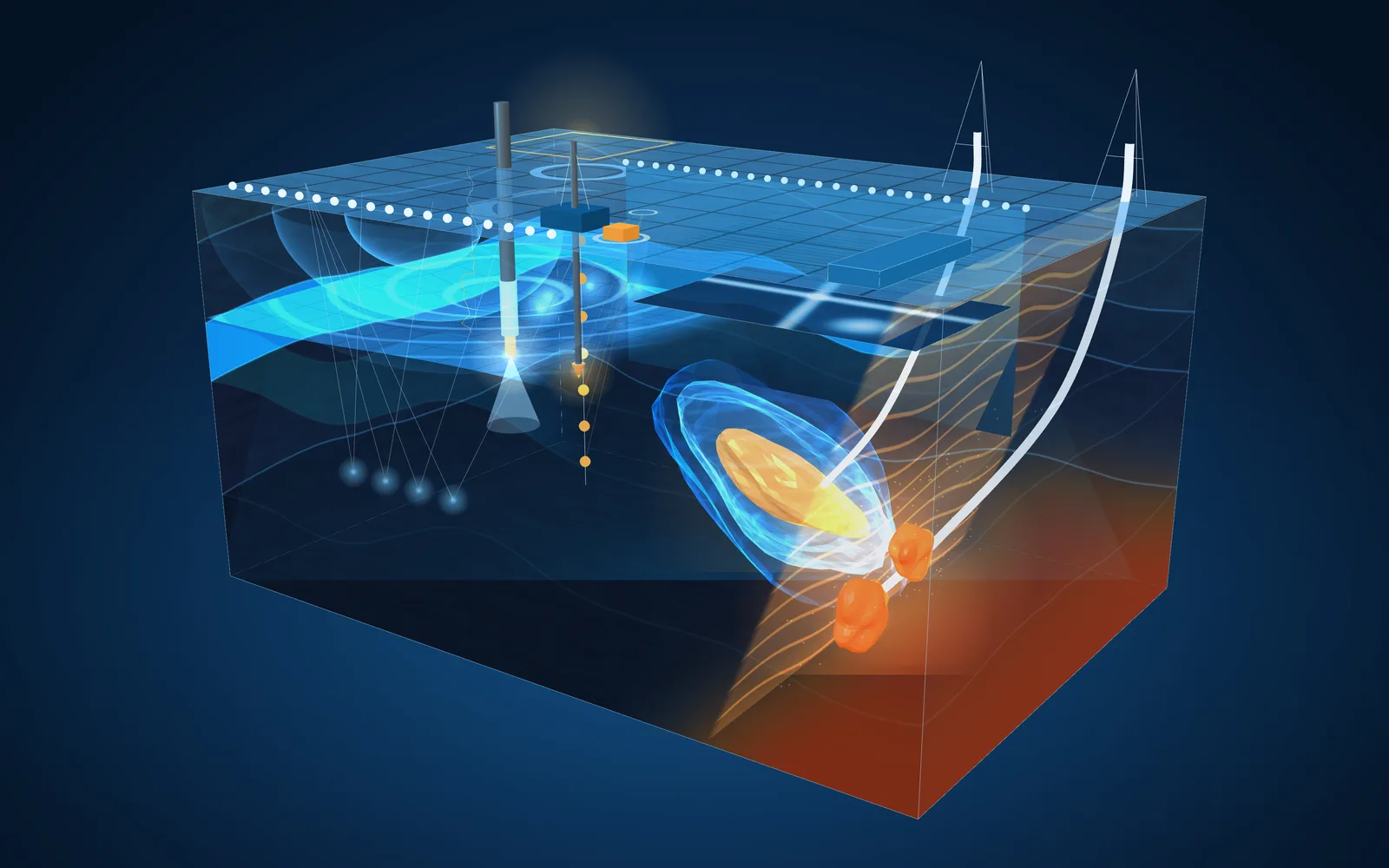
A single block of subsurface showing all the methods we use: from the surface to the borehole, each technique measures a different property, and together they build a consistent model of aquifers, geothermal reservoirs and mineralised bodies. Tap a number to open the service.

Illustrative diagram
  1. 1TDEM and TEM2Go
  2. 23D GPR
  3. 33D ERT and IP
  4. 4Refraction, MASW and HVSR
  5. 5Seismic reflection
  6. 6Downhole
  7. 7Seismoelectrics
  8. 8CPTU penetration tests
  9. 9Borehole logs and video
  10. 10Aquifer reservoir
  11. 11Geothermal reservoir
  12. 12Mineralised body
Listening to the subsurface

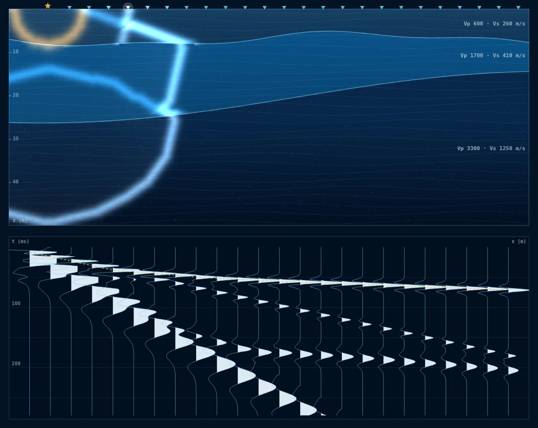
Wavefronts, refractions and reflections

A surface impact generates P-waves and S-waves that travel through the layers and refract and reflect at interfaces. Geophones record each arrival, and the shot record forms in real time: this is the data we use to derive subsurface velocities, thicknesses and geometry.

Illustrative diagram of a seismic survey: P- and S-wavefronts travelling through three layers with refractions and reflections, surface geophones and a shot record forming in real time
Illustrative diagram
  • P-waves
  • S-waves
  • Reflected waves
  • Seismic traces, variable area
New for 2026

New equipment for 2026

Our in-house equipment range is expanding with two systems that make surveys of the near surface and shallow aquifers faster and more continuous.

TDEM · TEM2Go

TEM2Go, backpack TDEM system

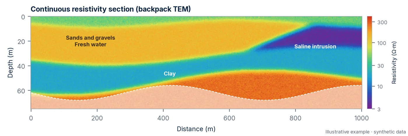
A time-domain electromagnetic system carried by two operators, with wireless transmitter and receiver units 15–20 m apart, GPS on both units and real-time inversion. It can survey around 1 km of profile in 10–15 minutes, with an investigation depth of up to approximately 75 m.

  • 0–75 m depending on resistivity
  • ~1 km in 10–15 minutes
  • Real time inversion in the field
Continuous resistivity section over 1 km from backpack TDEM, showing freshwater sands and gravels, a saline intrusion wedge and basal clay: illustrative synthetic data
Illustrative example using synthetic data: continuous resistivity section over 1 km.

This complements deeper sTEM and WalkTEM2 TDEM soundings (200–600 m). Electromagnetic surveys
3D ground-penetrating radar

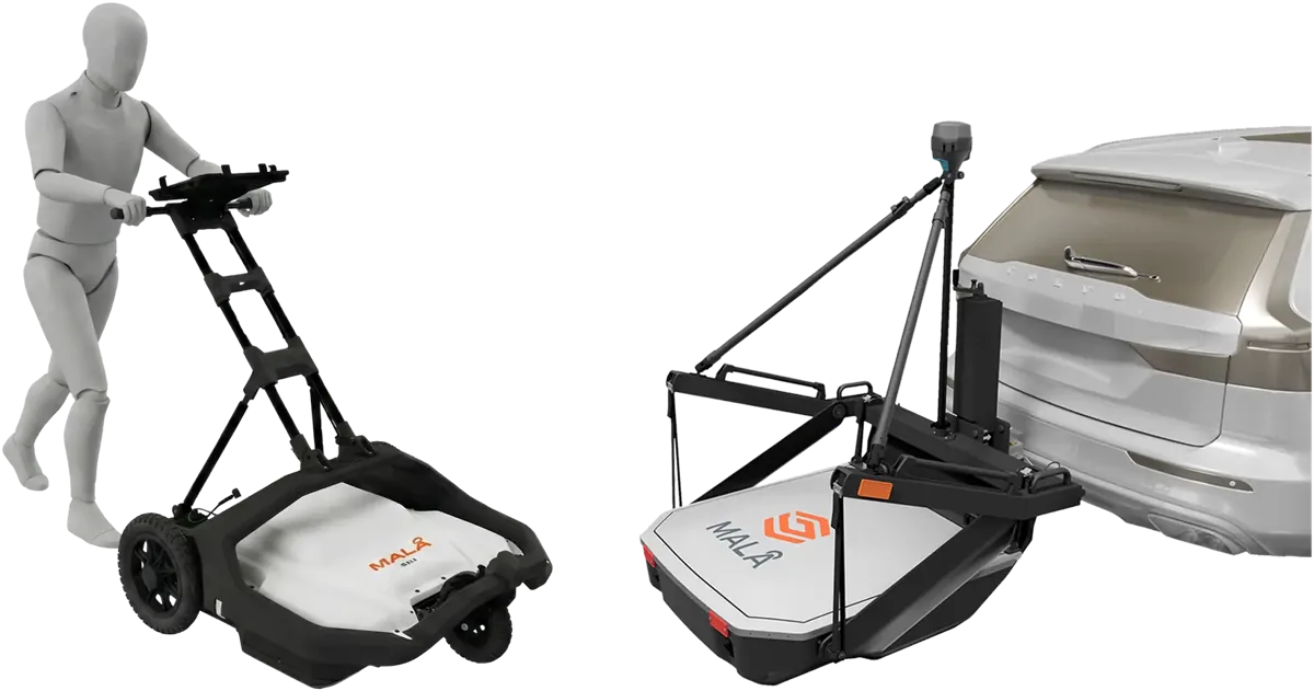
MALÅ 30-channel multi-antenna ground-penetrating radar

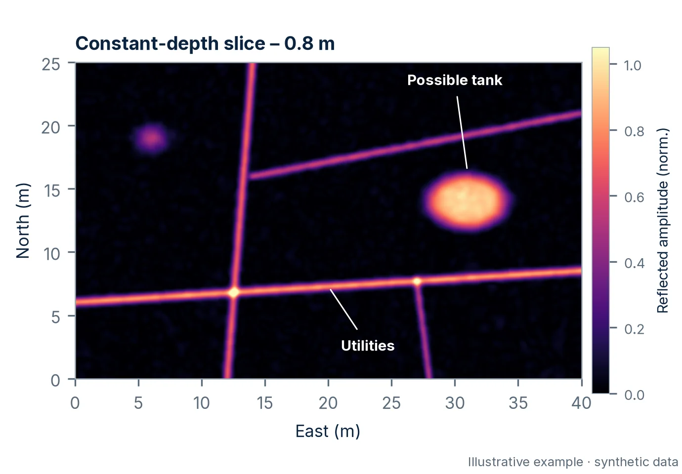
An antenna array acquires dozens of closely spaced parallel profiles in a single pass. Using GNSS or total-station positioning, we produce a continuous 3D volume and depth slices showing buried utilities, tanks and cavities. The equipment is owned by Sismoelettrica.

  • 30 channels in a single pass
  • 0–5 m typical range
  • CAD · GIS deliverables
MALÅ multi-channel ground-penetrating radar system in push and vehicle-towed configurations
MALÅ multi-channel ground-penetrating radar system: manufacturer reference image.
Ground-penetrating radar depth slice at 0.8 m showing a network of buried utilities and an anomaly consistent with a tank: illustrative synthetic data
Illustrative example using synthetic data: depth slice at 0.8 m.

3D multi-antenna ground-penetrating radar

Multi-method approach

From satellite data to the drilling location

Four investigation stages, each covering a smaller area at a higher level of detail. Each stage concludes with a decision point—to proceed, revise the approach or stop—and the results are delivered in GIS format for verification by the client.

  1. 01

    Satellite data and existing information

    1,000–10,000 km²

    Multispectral and hyperspectral imagery (Sentinel-2, ASTER, PRISMA, EnMAP), radar and digital terrain models, together with geological maps, airborne geophysics and well records. We identify lineaments, alteration and areas for further investigation.

    • Sentinel-2
    • ASTER
    • PRISMA
    • EnMAP
    • Radar and DEM
  2. 02

    Drone surveys

    10–100 km²

    Over selected areas, drone-based magnetometry and gamma-ray spectrometry (K, U, Th) are carried out using VTOL fixed-wing and multirotor platforms operated by specialist technology providers. The anomalies narrow the search to a few sectors.

    • Magnetometry
    • K-U-Th radiometry
    • LiDAR
  3. 03

    Ground geophysics and geochemistry

    1–10 km²

    Gravimetry, TDEM, ERT/IP tomography and seismoelectric soundings investigate anomalies at depth; geochemical analysis of soil, sediment, rock and water, in collaboration with the University of Florence, helps confirm their nature.

    • Gravimetry
    • TDEM
    • ERT/IP
    • Seismoelectric
    • Geochemistry
  4. 04

    Model and drilling

    Drilling location

    Data are integrated into a model with associated uncertainty; targets are ranked and borehole or well locations defined. We monitor drilling using borehole geophysical logging and video inspection.

    • 3D model
    • Target ranking
    • Borehole logging
Aquifer and geothermal reservoirs

Know where to drill before drilling

A well drilled in the wrong place costs as much as one drilled in the right place. For aquifer and geothermal reservoir exploration, we combine electrical resistivity tomography, seismoelectric soundings and, where needed, TDEM soundings, correlating the results with the geology and existing wells in the area.

The result is a report with 2D and 3D models and practical recommendations: the proposed drilling location, the aquifer or geothermal levels to target, the recommended depth and an alternative location. Once the well has been drilled, geophysical logs and video inspection verify the formations encountered and the quality of the installation.

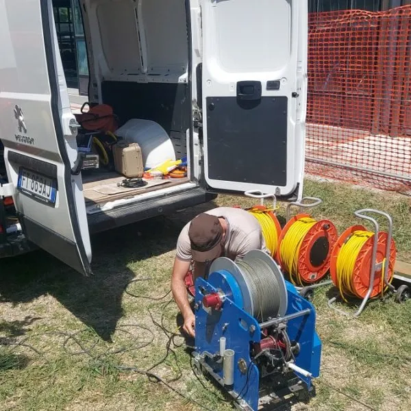
Sismoelettrica technician with a motorised winch and cable reels behind a van during geophysical borehole logging
Geophysical borehole logging with a motorised winch.
Why Sismoelettrica

Integrated methods, in-house equipment, clear answers

Comprehensive mapping

The data provide a subsurface map of geological, geotechnical and hydrogeological features—not just a single isolated measurement.

End-to-end service

From surface geophysical surveys to hydrogeological and geotechnical analysis, through to visual inspection of completed water-capture structures.

Controlled time and costs

Our own equipment—a Pagani penetrometer, 96-channel MAE georesistivimeter, SARA seismograph, TDEM systems and TEM2Go, and MALÅ multi-antenna ground-penetrating radar—combined with a single team reduces handovers and waiting times.

Applied research

Collaborations with the University of Florence and the University of Siena, and innovative methods such as seismoelectric surveys and permeability and porosity tomography.

Where we work

From our Florence base, across Italy and beyond

We work for private clients, companies and public bodies, and welcome new collaborations with professionals and technical consultancies.

Base

Florence

Our operational base, equipment store and technical office are in Florence. From here, we organise surveys, data processing and reporting.

Italy

Projects throughout Italy

Our portable equipment enables us to carry out surveys and in-situ tests throughout Italy.

Clients

Who we have worked with

Public bodies, construction companies, engineering firms and businesses in the water sector.

  • Comune di Livigno
  • Comune di Firenze
  • Comune di Alto Reno Terme
  • Pizzarotti S.p.A.
  • Ingegnerie Toscane
  • Sorgenti Italiane
  • Riccoboni
  • CSO Scandicci
  • and other public bodies and companies
In the news

Technical mission in Tanzania, October 2025

Technical mission and meetings with the Geological Survey of Tanzania, the Ministry of Minerals and the University of Dar es Salaam (October 2025).

Read the press coverage
  • University of Florence
  • Daily News (Tanzania)
  • The Respondents (Tanzania)
  • Ministry of Minerals of Tanzania

Request a quotation for your investigation

Location, objective and timescale: with this information, we can propose the most suitable methods for the geological setting and provide a detailed quotation.

Brochure

Download the brochure

Sismoelettrica's services, methods and equipment in one document, to read offline or forward to colleagues.

CallWhatsAppQuotation